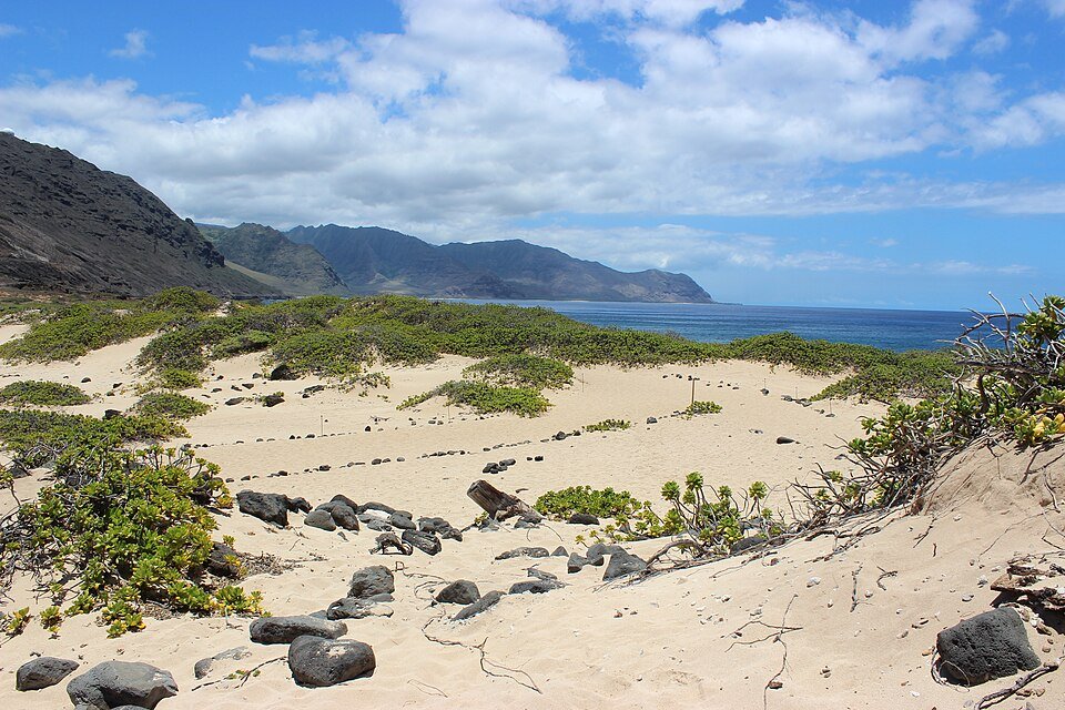
Kaʻena Point looks like a simple hike on a map: follow the coast to Oʻahu’s northwest tip and look for seabirds. The decision that matters is which side you can legally and safely approach from today. The Mokuleʻia (north) and Keawaʻula (west) approaches are different trips, and storm damage has changed access. This guide separates normal trail descriptions from the current closure notices so you can decide whether to go at all.
Access review: November 4, 2026. In its more recent November 2 park notices, Hawaiʻi DLNR says Kaʻena Point’s permitted vehicle access road is closed because of saturated conditions and the Keawaʻula Trail remains closed. West-side vehicle access remains restricted past the restroom parking lot. Older park information describing an October 6 reopening of the Mokuleʻia vehicle road is superseded by the newer closure notice. Check the current state park page before traveling; this is not a guarantee that pedestrian routes are open on your date.
At a glance: which approach fits your visit?
| Approach | Normal experience | Current decision |
|---|---|---|
| Mokuleʻia / North Shore | About 2.5 miles each way from the end of the paved road, across an exposed coastal plain, limestone reef and dunes. | DLNR’s November 2 notice closes permitted vehicle access because of saturated roads. A vehicle permit does not override this. Verify pedestrian access independently with State Parks before attempting the hike. |
| Keawaʻula / Waiʻanae | About 2.5 miles each way, below cliffs along a rocky, eroded coastline. | The Keawaʻula Trail is closed. Do not pass closures or try to reach the point from this trail until DLNR announces reopening. |
| A short beach stop | Spend time near a lawful parking area without committing to the point. | The Keawaʻula comfort-station parking area has limited access according to DLNR; confirm the latest gate, beach and ocean-safety conditions before deciding on even a short stop. |
DLNR publishes the normal route descriptions, but a general trail description is not a reopening notice. Because storm impacts and saturated ground can change access quickly, confirm same-day information rather than relying on a map app or an older blog photo.
State park versus Natural Area Reserve: why the distinction matters
Kaʻena Point State Park includes the north-side Mokuleʻia and west-side Keawaʻula sections. Beyond them, the Kaʻena Point Natural Area Reserve protects a fragile dune ecosystem and native wildlife. The reserve is not simply an open beach shortcut. Follow marked routes and signs, stay out of sensitive nesting areas, and respect temporary barriers even if other visitors are crossing them.
The point also has deep cultural meaning, including the traditional concept of leina a ka ʻuhane, a place associated with the passage of spirits. Give the landscape the same care you would give a cultural site: no collecting, carving, off-trail wandering or treating seabird habitat as a photo prop. The state reserve overview provides cultural and ecological context.
How long and how difficult is the hike?
From either traditional trailhead, DLNR describes approximately 2.5 miles one way to the reserve, or about 5 miles round trip if you return by the same route. That distance is only a baseline: walking from legal parking, detours, conditions and time spent observing wildlife may increase the outing. Neither side is a paved, shaded family stroll.
- Exposure: this is hot, dry coast with very little shade. Wind can disguise heat, and the return can feel harder.
- Surface: expect sand, loose rocks and old road sections; the west route has eroded portions that are not safe to improvise around.
- Facilities: there is no drinking water along either route and no comfort station on the Mokuleʻia side. Do not assume a west-side facility is available simply because the parking lot is partly accessible.
- Timing: assess remaining daylight, weather, surf and the ability of your slowest walker. The state park lists normal hours of 6 a.m. to 7 p.m., but closures supersede published hours.
- Navigation: download the route for orientation, then follow the park’s signs. Do not use a satellite map to bypass a closed gate or shoreline section.
If your group includes inexperienced walkers, small children, or anyone who needs frequent breaks, a shorter approved coastal activity may be more suitable. Our Hawaiʻi hiking-trail decision guide and weather and trail-closure safety guide can help you make that call.
What makes the reserve worth protecting?
The reserve supports Laysan albatrosses, native plants, nesting seabirds and endangered Hawaiian monk seals. DLNR describes it as a rare surviving coastal dune ecosystem in the main Hawaiian Islands. Wildlife sightings depend on season and conditions; never plan as though an animal will be present or accessible for a photograph.
Stay on designated paths and observe without approaching. Birds may nest directly on the ground or in burrows. Never cross a wildlife barrier, step into a nesting area, touch an animal or use a drone to get a closer view. State Parks prohibits dogs, drones and camping in the park and reserve.
If a monk seal is resting, NOAA recommends at least 50 feet of separation; for a mother and pup, allow at least 150 feet and stay behind all temporary barriers. These are NOAA viewing recommendations, distinct from enforceable laws against harassment. If wildlife appears disturbed, back away farther. Read NOAA’s Hawaiʻi wildlife-viewing guidance and our wildlife-distance comparison before traveling.
Can you drive beyond the Mokuleʻia gate?
Not as an ordinary sightseeing visitor. DLNR operates a special vehicle-access permit for designated roads beyond the Mokuleʻia gate. A current valid permit and 2026 decal are required; older 2024–2025 decals are no longer valid. It is a managed-access program, not permission to drive anywhere off road. Crucially, the November 2, 2026 saturated-road closure overrides permit access. Do not assume that having a 4WD vehicle, a decal, or a gate code makes a closed road legal to enter.
A practical no-go checklist
Before you commit to a long drive from Waikīkī or another Oʻahu base, confirm all of the following:
- The latest DLNR park notice gives a current status for your chosen side; if the trail or road is closed, remove it from the plan.
- You have a lawful place to park or an arranged pickup, with access hours understood. Do not park across a gate or in a residential driveway.
- The weather, surf, heat and ground conditions are suitable for a long exposed walk. Do not use rocky coastal ledges as an alternative to a closed trail.
- Everyone has sufficient water, food, sun protection, traction, basic first aid and a reliable return plan.
- The group is comfortable leaving wildlife alone and returning early if signs, barriers or conditions dictate.
There is no obligation to finish the walk. A trip saved for an open, safer day is better than a difficult rescue or a disturbance to protected wildlife. For low-waste preparation, see the reusable Hawaiʻi packing guide.
How to fit Kaʻena Point into an Oʻahu itinerary
Kaʻena Point should be an entirely optional half- to full-day priority, not a detour squeezed between a North Shore beach and an evening reservation. The north and west approaches do not join by a public vehicle road around the point. Choose one side only after confirming access, and include the return drive. If the trail is closed, move this experience to another day or select an open activity from our Oʻahu island guide and seven-day Oʻahu itinerary. The respectful visitor guide offers useful context for fragile coastlines and nearby communities.
Frequently asked questions
Is Kaʻena Point open right now?
The answer depends on the exact section and route. DLNR’s November 2, 2026 notice closes the Keawaʻula Trail and the Mokuleʻia permitted vehicle road. The reserve’s ordinary visitor information does not cancel these specific restrictions. Check current park notices for the route you intend to use.
Do I need to pay for a hiking permit?
DLNR’s general state park and trail descriptions do not list an ordinary day-hiking reservation for the standard pedestrian route. Vehicle entry beyond the Mokuleʻia gate is a separate permit system. A road closure applies regardless of whether you hold that permit.
Can I take my dog or fly a drone?
No. DLNR prohibits dogs and drones in Kaʻena Point State Park and its sensitive reserve habitat. This is especially important around ground-nesting seabirds and resting monk seals.
Is it a good swimming beach?
This guide does not recommend swimming as part of the Kaʻena Point hike. The coast is exposed, shore conditions can be hazardous, and the Keawaʻula section is described by DLNR as suitable for swimming only during calm summer conditions. Check lifeguard advice and ocean conditions separately; never enter the water as a way around a closure.
Official sources and photo credit
Access checked November 4, 2026: DLNR park notices (November 2 update); Kaʻena Point State Park; state trail details; vehicle access rules; Natural Area Reserve; and NOAA wildlife viewing guidance. Older park page headers can retain superseded reopening information; use the most recently dated notice and heed on-site closures.
Featured photograph: coastal dune habitat at Kaʻena Point, Oʻahu, photographed July 2015 by Aaron Zhu / Wikimedia Commons, licensed CC BY-SA 3.0; resized for web use. The historical image does not depict November 2026 access conditions.
